| << | April 2025 | >> | ||||
| S | M | T | W | T | F | S |
| 1 | 2 | 3 | 4 | 5 | ||
| 6 | 7 | 8 | 9 | 10 | 11 | 12 |
| 13 | 14 | 15 | 16 | 17 | 18 | 19 |
| 20 | 21 | 22 | 23 | 24 | 25 | 26 |
| 27 | 28 | 29 | 30 | |||
Finally-Spring at Killington.
Winter Storm Watch issued for Killington.
Heavy snow expected.
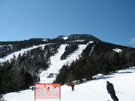
Oxymoron-Walter and a "Slow Sign" with Killington Peak in the background.
Oxymoron-Walter and a "Slow Sign" with Killington Peak in the background.
Finally....spring arrived at Killington.
Beautiful sunny skies complimented temperatures in the low to mid 30's to bring spring skiing to the Killington resort. From Bear Mountain to the Canyons below Killington Peak, bright sunshine bathed the region; softening up snow surfaces in the process.
High speed cruising was once again the methode du jour with few bumps to be found around the resort early this morning. The situation should change later in the day, but with minimal skier traffic it is unlikely that big spring bumps will form before the weekend.
Superstar, Outer Limits, the Stash, Bear Claw, Wild Fire, and Skyburst were all groomed flat. All were rated do overs. Outer Limits was developing a soft cream in the full on early morning sun.
Upper Dream Maker and Needles Eye were flat and fast with small skier created bumplets. Neither trail had been groomed overnight, yielding a crisp finish common to spring skiing on trails with little skier traffic.
At Killington Peak the Canyon Trilogy was in all it's spring glory. East Fall with it's southern exposure was creaming up nicely. Double Dipper was softening up with some light corn. Cascade, in the shadows due to it's north face, was firm with a machine groomed granular surface down it's double fall line. Rime, Reason, and Ridge Run were skiing nice. Ridge Run had firm bumps in the shadows down skiers left, but due to the slight pitch they were easily navigable.
Winter Storm Watch issued for Killington Vermont
KILLINGTON ... 306 PM EDT WED MAR 30 2011
...WINTER STORM WATCH REMAINS IN EFFECT FROM LATE THURSDAY NIGHT THROUGH LATE FRIDAY NIGHT...
THE NATIONAL WEATHER SERVICE IN BURLINGTON CONTINUES THE WINTER STORM WATCH...FROM LATE THURSDAY NIGHT THROUGH LATE FRIDAY NIGHT.
* LOCATIONS...ALL OF CENTRAL AND NORTHERN VERMONT...AND THE NORTHERN ADIRONDACKS OF NEW YORK...INCLUDING THE CHAMPLAIN VALLEY
* HAZARD TYPES...MODERATE TO HEAVY WET SNOWFALL.
* ACCUMULATIONS...6 TO 12 INCHES OF SNOW...WITH LOCALIZED HIGHER AMOUNTS ACROSS THE MOUNTAINS OF CENTRAL AND NORTHERN VERMONT.
* TIMING...SNOW WILL OVERSPREAD THE REGION THURSDAY NIGHT AND BECOME HEAVY AT TIMES ON FRIDAY BEFORE TAPERING TO SNOW SHOWERS FRIDAY NIGHT.
* IMPACTS...HAZARDOUS TRAVEL CONDITIONS CAN BE EXPECTED...ESPECIALLY DURING THE FRIDAY MORNING COMMUTE. IN ADDITION...SCATTERED POWER OUTAGES WILL BE POSSIBLE DUE TO THE HEAVY WET SNOW...ESPECIALLY ACROSS THE HIGHER ELEVATIONS.
* WINDS...NORTH 10 TO 20 MPH WITH GUSTS UP TO 30 MPH.
* TEMPERATURES...IN THE UPPER 20S TO MID 30S DURING THE STORM.
PRECAUTIONARY/PREPAREDNESS ACTIONS...
A WINTER STORM WATCH MEANS THERE IS A POTENTIAL FOR SIGNIFICANT SNOW...SLEET...OR ICE ACCUMULATIONS THAT MAY IMPACT TRAVEL. CONTINUE TO MONITOR THE LATEST FORECASTS.
With fresh snow on the way, and the Bear Mountain Mogul Challenge this weekend, it is time to get to Killington for some late season skiing and riding. Let it Snow!
|
Designed on a MAC Hosted on Network Solutions. |