| << | April 2025 | >> | ||||
| S | M | T | W | T | F | S |
| 1 | 2 | 3 | 4 | 5 | ||
| 6 | 7 | 8 | 9 | 10 | 11 | 12 |
| 13 | 14 | 15 | 16 | 17 | 18 | 19 |
| 20 | 21 | 22 | 23 | 24 | 25 | 26 |
| 27 | 28 | 29 | 30 | |||
Killington get's ready for the 2009 season
An exploratory hike around the resort
Snow Shed Crossover

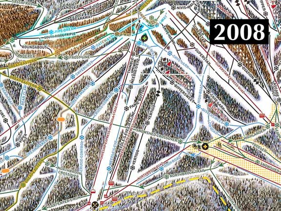
2009 Killington Ski Map depicting Sky Peak area
2009 Killington Ski Map depicting Sky Peak area
In the modern day Killington, every skier or rider has been on the Snow Shed Crossover trail at some point in their Killington adventure. Love it, or loath it, the Snow Shed Crossover was an inescapable constant in being able to traverse across wide swaths of the resort between Killington's 6 mountains.
In it's audacious plan to remake the on slope experience at the resort, Killington/Pico Ski Resort Partners has actively worked to eliminate the Snow Shed Crossover when the resort opens for the 2009 season. It is way to early to tell how skiers and riders will react to the changes. Will they see it as a very bold move to reshape the resort? Or will they get frustrated as they try to figure out new strategies for maneuvering around the mountain? My guess is that at least in the beginning, it will be a combination of both. But over time, I suspect the audacity to change the mountain will win out as skiers and riders of all levels enjoy the expanded terrain.
With this huge change to the resort in mind, Mary and I began our hike along the work road formerly know as the Snow Shed Crossover.
Our hike across Sky Peak begins at the K1 Base Lodge. On the 2008 ski map, the route is fairly obvious. We hike from the K1 parking lot up Highlander to the Snow Shed Crossover. From there we link up with Great Eastern after traversing across Vertigo, Needles Eye, and Cruise Control. Our first hike took us along Great Eastern to Frostline to Gateway to Sky Peak Lift top terminal area. We exited by various routes. On one hike, we followed the 2008 trail formerly known as Cruise Control (now Great Eastern in 2009) back to the Snow Shed Crossover. On subsequent hikes, we went down Bittersweet to check out new trail work being done to make it a "Blue" trail. On the 2008 map, it all looks so simple. On the 2009 map, our route ranges between difficult to follow to no where to be found.
|
| 2008 Ski Map with Snow Shed Crossover clearly marked (Click to enlarge.) |
Of course, as we realized, the Snow Shed Crossover is still there. The trees shown on the 2009 ski map where the Snow Shed Crossover used to be are just artistic license. It's still there, although it is now reduced to the lowly status of a work road to move vehicles (and hikers) around the mountain.
In the process of converting the Snow Shed Crossover to a work road, and rerouting Great Eastern, there are indications all over the place that barriers will be erected to redirect skier and rider traffic along the paths outlined on the 2009 map. In some instances, where The Stash and the trail formerly known as Great Eastern(now known as Bear Claw) meet, a hard barrier wall is being installed. In other areas, metal lined post holes of various shapes are set in concrete. They are clearly set at strategic locations to hold some type of barrier to redirect skier traffic. If you are a Killington aficionado, when you ski Sky Peak for the first time this season, be very careful about making high speed turns onto what you thought was the Snow Shed Crossover. We particularly noted the left turn off of Sky Burst during our hike as an area where unsuspecting skiers and riders could wind up in trouble. Running into any kind of barrier can clearly ruin your day.
If you would like to compare the ski maps for 2008 and 2009 directly, I have merged the 2 in an animated gif(for simplicities sake). It is a rather large file. You can download it here.
In addition to the spots where barriers will be installed, all along our hiking route we saw impressive feats of terra forming to reshape Killington. Major explosive work followed by heavy excavations have been completed to re-route Great Eastern, reshape Sky Peak, create "The Stash" and change BitterSweet. And of course, the whole area around the top of the Sky Peak Quad has been completely transformed.
In the next couple of days, I will follow up with a description and pictures of each section. Tomorrow I will look in detail at the impressive work being done to build "The Stash".
|
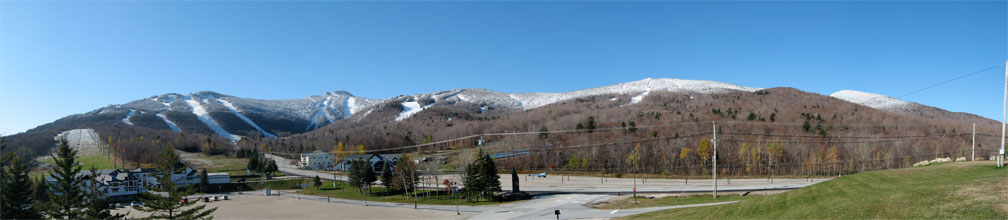
| First significant snowfall of the 2008/2009 season blankets Killington (Click to enlarge.) |
-----Update------ Late yesterday and into the night, Killington Peak experienced it's first significant snow fall for the 2008/2009 season. News accounts indicate that as much as 7 inches accumulated at the peak, although it is undoubtedly wet and sloppy. The snow line seemed to extend down the mountain to about the 2500 foot level, almost making it to the K1 Base Lodge (~2200 feet).
Let it snow!

|
Designed on a MAC Hosted on Network Solutions. |